![](/images/other/stat-length.png)
![Percorso A piedi Rot am See - SAV blauer Balken Weglinie 2. Grades Blaufelden-Leofels - Photo](https://media.geolcdn.com/t/1900/400/ext.pjpeg?maxdim=2&url=https%3A%2F%2Fmedia.geolcdn.com%2Ff%2F2707a45b-c504-44f1-bf11-267cb7a3f412.jpeg)
SAV blauer Balken Weglinie 2. Grades Blaufelden-Leofels
SityTrail - itinéraires balisés pédestres
Tous les sentiers balisés d’Europe PRO
![Lunghezza](/images/other/stat-length.png)
Lunghezza
5,9 km
![Altitudine massima](https://static1.geolcdn.com/siteimages/upload/files/1508320355ic_sort_altitude_max_24dp.png)
Altitudine massima
451 m
![Dislivello positivo](https://static1.geolcdn.com/siteimages/upload/files/1508320355ic_sort_den_pos_24dp.png)
Dislivello positivo
172 m
![Km-Effort](/images/other/stat-length.png)
Km-Effort
8,3 km
![Altitudine minima](https://static1.geolcdn.com/siteimages/upload/files/1508320355ic_sort_altitude_min_24dp.png)
Altitudine minima
311 m
![Dislivello negativo](https://static1.geolcdn.com/siteimages/upload/files/1508320355ic_sort_den_neg_24dp.png)
Dislivello negativo
191 m
![Boucle](https://static1.geolcdn.com/siteimages/upload/files/16400158638029165_repeat_loop_refresh_sync_direction_icon.png)
Boucle
No
Tag
Data di creazione :
2022-02-11 12:47:48.584
Ultima modifica :
2022-02-11 12:47:48.584
![A piedi](https://static1.geolcdn.com/sitytour/trail-icons/100.png)
1h52
Difficoltà : Facile
![Scannerizza questo codice QR per aprire il percorso nell'applicazione SityTrail](https://capi.geolives.com/qq0zvz2zws4bq2lad0pu/sitytour/trails/3087942/qr.png?size=200)
Applicazione GPS da escursionismo GRATUITA
Chi siamo
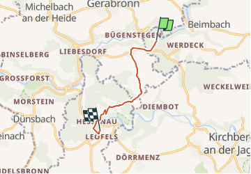
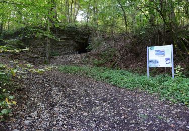
Percorso A piedi di 5,9 km da scoprire a Baden-Württemberg, Landkreis Schwäbisch Hall, Rot am See. Questo percorso è proposto da SityTrail - itinéraires balisés pédestres.
Descrizione
Trail created by Schwäbischer Albverein.
Symbol: Blauer Strich auf weißem Grund
Localizzazione
Paese:
Germany
Regione :
Baden-Württemberg
Dipartimento/Provincia :
Landkreis Schwäbisch Hall
Comune :
Rot am See
Località :
Unknown
Partenza:(Dec)
Partenza:(UTM)
568742 ; 5454314 (32U) N.
Commenti
Percorsi nelle vicinanze
![Percorso A piedi Diebach - Krone - Photo](https://media.geolcdn.com/t/375/260/ext.jpg?maxdim=2&url=https%3A%2F%2Fmedia.geolcdn.com%2Ff%2F85c9ea59-24b4-4aff-b9cc-7992c08d3550.jpeg)
![A piedi A piedi](https://static1.geolcdn.com/sitytour/trail-icons/100.png)
Krone
A piedi
Facile
Diebach,
Baviera,
Landkreis Ansbach,
Germany
![](/images/other/stat-length.png)
10,9 km | 13,2 km-effort
2h 59min
![](https://static1.geolcdn.com/siteimages/upload/files/16400158638029165_repeat_loop_refresh_sync_direction_icon.png)
Sì
![Percorso A piedi Niederstetten - Liebliches Taubertal 24 Vorbach - Photo](https://media.geolcdn.com/t/375/260/ext.jpg?maxdim=2&url=https%3A%2F%2Fmedia.geolcdn.com%2Ff%2Fb02915de-f11c-4379-88bf-c89e4b85aa5a.jpeg)
![A piedi A piedi](https://static1.geolcdn.com/sitytour/trail-icons/100.png)
Liebliches Taubertal 24 Vorbach
A piedi
Facile
Niederstetten,
Baden-Württemberg,
Main-Tauber-Kreis,
Germany
![](/images/other/stat-length.png)
12,2 km | 16,6 km-effort
3h 45min
![](https://static1.geolcdn.com/siteimages/upload/files/16400158638029165_repeat_loop_refresh_sync_direction_icon.png)
Sì
![Percorso A piedi Dörzbach - Pfad der Stille (Dörzbach) - Photo](https://media.geolcdn.com/t/375/260/ext.jpg?maxdim=2&url=https%3A%2F%2Fmedia.geolcdn.com%2Ff%2F14b761e2-b5ea-4d22-a494-19152d28002e.jpeg)
![A piedi A piedi](https://static1.geolcdn.com/sitytour/trail-icons/100.png)
Pfad der Stille (Dörzbach)
A piedi
Facile
Dörzbach,
Baden-Württemberg,
Hohenlohekreis,
Germany
![](/images/other/stat-length.png)
6,5 km | 8,9 km-effort
2h 1min
![](https://static1.geolcdn.com/siteimages/upload/files/16400158638029165_repeat_loop_refresh_sync_direction_icon.png)
No
![Percorso A piedi Schwäbisch Hall - Rundwanderweg Schwäbisch Hall 1 - Photo](https://media.geolcdn.com/t/375/260/ext.jpg?maxdim=2&url=https%3A%2F%2Fmedia.geolcdn.com%2Ff%2F8208d8c3-e7ba-4550-826a-ea423a873b16.jpeg)
![A piedi A piedi](https://static1.geolcdn.com/sitytour/trail-icons/100.png)
Rundwanderweg Schwäbisch Hall 1
A piedi
Facile
Schwäbisch Hall,
Baden-Württemberg,
Landkreis Schwäbisch Hall,
Germany
![](/images/other/stat-length.png)
14,2 km | 18,8 km-effort
4h 15min
![](https://static1.geolcdn.com/siteimages/upload/files/16400158638029165_repeat_loop_refresh_sync_direction_icon.png)
Sì
![Percorso A piedi Rothenburg ob der Tauber - Rothenburger W4 - Natursteig - Photo](https://media.geolcdn.com/t/375/260/ext.jpg?maxdim=2&url=https%3A%2F%2Fmedia.geolcdn.com%2Ff%2Fd569b6e8-20ae-4c7f-9f17-9f200af7a901.jpeg)
![A piedi A piedi](https://static1.geolcdn.com/sitytour/trail-icons/100.png)
Rothenburger W4 - Natursteig
A piedi
Facile
Rothenburg ob der Tauber,
Baviera,
Landkreis Ansbach,
Germany
![](/images/other/stat-length.png)
6,8 km | 8,4 km-effort
1h 54min
![](https://static1.geolcdn.com/siteimages/upload/files/16400158638029165_repeat_loop_refresh_sync_direction_icon.png)
No
![Percorso A piedi Rothenburg ob der Tauber - Rothenburger W3 - Kleiner Taubertalweg - Photo](https://media.geolcdn.com/t/375/260/ext.jpg?maxdim=2&url=https%3A%2F%2Fmedia.geolcdn.com%2Ff%2F2d219dd4-d118-4615-825c-f1e0ab382514.jpeg)
![A piedi A piedi](https://static1.geolcdn.com/sitytour/trail-icons/100.png)
Rothenburger W3 - Kleiner Taubertalweg
A piedi
Facile
Rothenburg ob der Tauber,
Baviera,
Landkreis Ansbach,
Germany
![](/images/other/stat-length.png)
4 km | 5,6 km-effort
1h 16min
![](https://static1.geolcdn.com/siteimages/upload/files/16400158638029165_repeat_loop_refresh_sync_direction_icon.png)
Sì
![Percorso A piedi Rothenburg ob der Tauber - Rothenburger W1 - Detwanger Weg - Photo](https://media.geolcdn.com/t/375/260/ext.jpg?maxdim=2&url=https%3A%2F%2Fmedia.geolcdn.com%2Ff%2F3855134a-1211-4ce0-bb69-11a7db59eccd.jpeg)
![A piedi A piedi](https://static1.geolcdn.com/sitytour/trail-icons/100.png)
Rothenburger W1 - Detwanger Weg
A piedi
Facile
Rothenburg ob der Tauber,
Baviera,
Landkreis Ansbach,
Germany
![](/images/other/stat-length.png)
3,5 km | 4,8 km-effort
1h 6min
![](https://static1.geolcdn.com/siteimages/upload/files/16400158638029165_repeat_loop_refresh_sync_direction_icon.png)
Sì
![Percorso A piedi Rothenburg ob der Tauber - Rothenburger W2 - Zu den Rothenburger Mühlen - Photo](https://media.geolcdn.com/t/375/260/ext.jpg?maxdim=2&url=https%3A%2F%2Fmedia.geolcdn.com%2Ff%2Ffd08601b-fa2a-4d50-9433-292f77fe7f6e.jpeg)
![A piedi A piedi](https://static1.geolcdn.com/sitytour/trail-icons/100.png)
Rothenburger W2 - Zu den Rothenburger Mühlen
A piedi
Facile
Rothenburg ob der Tauber,
Baviera,
Landkreis Ansbach,
Germany
![](/images/other/stat-length.png)
10,7 km | 13,3 km-effort
3h 1min
![](https://static1.geolcdn.com/siteimages/upload/files/16400158638029165_repeat_loop_refresh_sync_direction_icon.png)
Sì
![Percorso A piedi Wolpertshausen - Spuren der Vergangenheit - Photo](https://media.geolcdn.com/t/375/260/ext.jpg?maxdim=2&url=https%3A%2F%2Fmedia.geolcdn.com%2Ff%2F9511e109-23b6-45a9-8659-30609113d5b0.jpeg)
![A piedi A piedi](https://static1.geolcdn.com/sitytour/trail-icons/100.png)
Spuren der Vergangenheit
A piedi
Difficile
Wolpertshausen,
Baden-Württemberg,
Landkreis Schwäbisch Hall,
Germany
![](/images/other/stat-length.png)
25 km | 33 km-effort
7h 30min
![](https://static1.geolcdn.com/siteimages/upload/files/16400158638029165_repeat_loop_refresh_sync_direction_icon.png)
Sì